The mountains make their own weather!
By MWIS ambassador Mehmet Karatay:
You may have noticed that on the forecast for Friday 11 December 2020, the Cairngorms were forecast to be marginally colder than other mountainous regions of the UK. The story behind this shows that the mountains can indeed make their own weather.
Regardless of where you are, you've probably noticed that over the past few days we’ve had low cloud across most of the country and in particular over the mountains. This is where our story starts. The air closest the land, in meteorological terms, is called the ‘boundary layer’. Recently the boundary layer over the UK has become increasingly saturated and is causing all the low cloud both on and off the mountains.
By midday on Friday the UK is set to have south-easterly winds up its east coast and much lighter winds elsewhere. What does this wind do to the boundary layer? It blows some of it up the mountains. The key places in the UK where Friday’s wind meets the mountains are the Cairngorms and the Northwest Highlands.
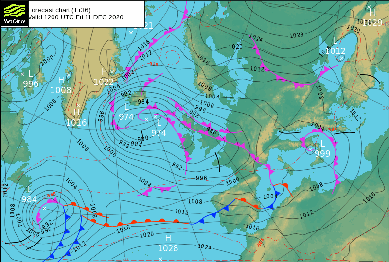
Forecast synoptic chart for 1200 on Friday showing stronger SE winds up the UK’s east coast and lighter elsewhere.
This is where things get more interesting. The air at sea level to the southeast of the Cairngorms is 6°C. As this air is forced over the southern Cairngorms it quickly reaches saturation. It cools at the wet air lapse rate as it gains height, which at this time of year is around 1°C/150m height gain. Some simple maths and we find that at the summit level the air becomes just below freezing. The air at this level, if the mountains weren’t present, is currently warmer than that. The presence of the Cairngorms themselves are causing the Cairngorms to be cold!
The Northwest Highlands are also in this air flow, so why don’t we see the same effect there? It’s because they are in the lee of the Cairngorms. Once the air is squeezed over the Cairngorms its wind speed increases and it becomes gusty. This gustiness causes turbulence downstream of the Cairngorms. This mixes the now-cold boundary layer air with the slightly warmer air higher up. The Northwest Highlands are affected by this mixed, slightly warmer air. Other mountainous areas don’t show the same effect at the moment simply because the winds are lighter and so the boundary layer air isn’t forced over them in the same way.